

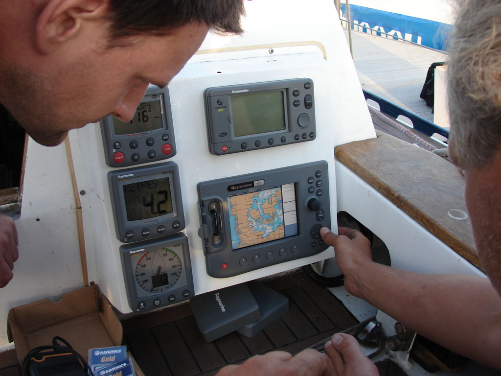
Navigation equipment on Delta is based on two independent systems, installed in the cabin and on a specially designed console on the desk in the cockpit with multifunction displays Raymarine C70. They work as radars/chartplotters. In addition to one of the systems, there is a PC with Raymarine software of RayTech RNS and special software to monitor the state of the navigation system in real-time mode. RayTech RNS Raymarine software makes it possible to obtain all data from the navigation system located at any place of the vessel.
Setting up Raymarine electronics to operate with GLONASS
Radio communications are established through Raymarine Ray215E stationary radio station. The navigation system also includes AIS transceiver Raymarine AIS 500. This provides receipt and transfer of boat data to other vessels and to the coastal service.
Indicator tools on the boat:
- Raymarine ST60+ Tridata provides accurate depth, speed, trip and water temperature information;
- Raymarine ST60+ Wind System provides accurate wind speed and direction information
Important parts of the navigation equipment are Raymarine SPX-5 Tiller Pilot and wireless autopilot control system S100, which enable boat handling from any place on it.
Safety facilities are represented by the wireless system Man Overboard LifeTag Raymarine.
In the event of a man overboard, the victim’s LifeTag signal is rapidly degraded by immersion in water, or as the distance between the victim and boat increase (typically 30 feet.) The LifeTag base station responds automatically by sounding an audible alarm onboard to roust other crew members. Each LifeTag is also fitted with a manual activation button. Pressing and holding the button for three seconds will manually trigger the system. This enables crew members to call for assistance in case of fire, flooding, medical emergency or other situations where an immediate response is needed.
- LifeTag can trigger the automatic man overboard in Raymarine SeaTalk compatible chartplotters, radars and instruments. SeaTalk network integration triggers vital actions automatically such as:
- Sounding the SeaTalk network MOB alarm, providing audible and visual alerts to all stations.
- Recording the GPS latitude/longitude of the MOB event, and making it the target waypoint on all connected SeaTalk devices
- Displaying critical search and rescue (SAR) data
- Lowering the range scale on connected Raymarine chartplotter and radar displays to the lowest possible range scale, enhancing seeing the victim on radar and facilitating maneuvering to recover the victim.
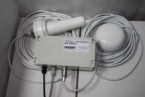
GLONASS SEEWAY RX-100 MODULE
The GLONASS system signal is processed by the Raymarine navigation equipment via a GLONASS/GPS module called SEEWAY RX-100. The module can receive signals both from GLONASS and GPS simultaneously. Marine navigation equipment from Raymarine Inc. can operate with GLONASS and GPS both simultaneously and separately: only in GLONASS mode or only in GPS mode.
Mikstmarine Company, the official distributor of Raymarine Inc. in Russia, has released a GLONASS/GPS receiver SEEWAY RX-100. This device enables reception, processing, and transmission of signals from satellite navigation systems GLONASS and GPS in the format readable by the Raymarine navigation equipment.
A pleasant feature of SEEWAY RX-100 is that there is no need to purchase special equipment. It is sufficient to replace a standard RAY125 GPS antenna, which is part of any Raymarine С-, СW-, E-, EW- and G-series multifunction displays, with the GLONASS SEEWAY RX-100 module equipped with a GLONASS/GPS antenna.
The GLONASS SEEWAY RX-100 module is based on a high-precision chip Navior 24 developed by Russian specialists. It can receive satellite and ground signals from various systems such as GLONASS, GPS, WAAS, and EGNOS. The precision of current coordinate identification is up to three meters. The chip used in the GLONASS SEEWAY RX-100 module allows you to select the mode for the preferable navigation system on any portable PC and get the following coordinates:
- GPS +GLONASS +WAAS/EGNOS
- GPS +WAAS/EGNOS only
- GLONASS +WAAS/EGNOS only
The user can thus apply a number of duplicate navigation systems to enhance the navigation precision and speed up information receipt. In GPS +GLONASS +WAAS/EGNOS mode, coordinates can be determined with the precision of about one meter.
The GLONASS SEEWAY RX-100 module will also please you with its price that does not greatly differ from that of a standard GPS antenna used with the Raymarine equipment. It is no doubt true that, for the first time in the Russian market, one can use the entire potential of GLONASS and GPS satellite groups in the equipment of the world’s leading manufacturer of marine electronics Raymarine Inc.
The pictures bellow show how the GLONASS SEEWAY RX-100 module is connected to the Raymarine multifunction navigation display (radar, navigator, and echo sounder).

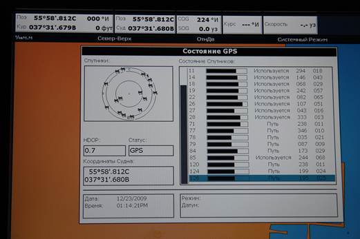
Software operation in real-time mode (GPS satellites are displayed in blue and the Russian GLONASS system operation is shown in red. The bars below show the level of signal reception).
The GLONASS/GPS signal processing module with antennas is provided by Mikstmarine Company.
GLONASS/GPS antenna testing results
The GLONASS SEEWAY RX-100 module is one of the first steps made by Russian and foreign users to really start using the GLONASS system.
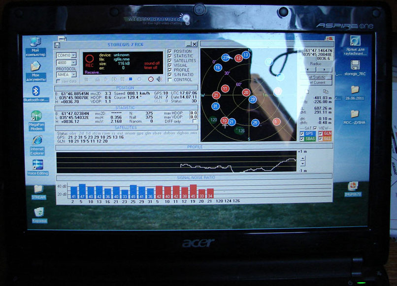
Software work at real time mode (blue indicates GPS, red shows the work of GLONASS, scales below indicate the receive level.
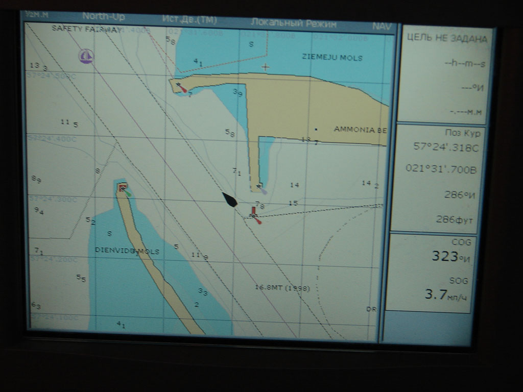
Latvia, Venspils, GLONASS working on Raymarine C70 Multifunction Display.

Latvia, Venspils, bark «SEDOV» on the AIS Radar.